|
|
|
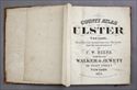
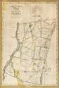
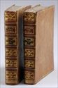
Lot
#221: BEERS, F.W., "COUNTY
ATLAS OF ULSTER, NEW YORK", NY (WALKER & JEWETT),
1875 |
|
|
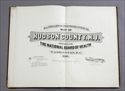
Lot
#222: SPIELMAN AND BRUSH, "SANITARY AND TOPOGRAPHICAL
MAP OF HUDSON COUNTY, N.J.", WASHINGTON, 1880 |
|
|
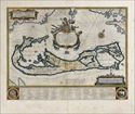
Lot
#223: (MAP) BLAEU, WILLEM, "MAPPA
AESTIVARUM INSULARUM ALIAS BARMUDAS _", AMSTERDAM,
(CIRCA 1635) |
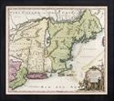 |
Lot
#224: HOMANN, JOHANN "NOVA ANGLIA_
_" NURENBERG (CA. 1720) |
|
|
Lot
#225: BURR, DANIEL "MAP OF THE COUNTY OF COLUMBIA," 1829 |
|
|
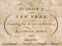
Lot
#226: LEWIS, SAMUEL "STATE OF NEW YORK," 1795 |
|
|
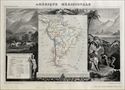
Lot
#227: (2 MAPS) LE MERCIER "AMERIQUE SEPTENTRIONALE" AND "AMERIQUE
MERICHONALE", PARIS, 1845 |
|
|
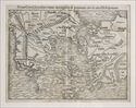
Lot
#228: (MAP) MUNSTER, S., "NOVA GRAECIA SECUNDUM
OMES LIUS REGRONES, _ _ HELLESPONTAMO", BASEL, 1552 |
 |
Lot
#229: GUER, "MOEURS ET USAGES DES TURCS, _ _",
PARIS, 1747 |
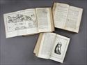 |
Lot
#230: TOURNEFORT, JOSEPH, "A VOYAGE INTO THE LEVANT",
LONDON, 1741 |